AuthaGraph bibliography and source provenance
Documentation index · Geometric context · Implementation notes
This bibliography distinguishes the analytic formula used by the C++ code from the earlier graphical construction, the official project description, the checked-in drawing sheet, and repository integration sources. Web resources were last checked on 2026-08-01.
Source hierarchy
When sources describe the construction at different levels, this implementation uses them in the following order:
- Narukawa’s 2022 peer-reviewed formula paper for the numeric forward transform and its distortion qualifications;
- Narukawa’s 2017 paper for the original polyhedral method, rectangular tiling, and applications;
- the official Narukawa Lab AuthaGraph page for the project’s own summary and terminology; and
- the checked-in A3 PDF for viewport measurement and visual registration.
The PDF is not used to derive the projection formula. Where the analytic method and the earlier drawing differ slightly, the formula paper controls the mathematics and the drawing controls only the compatibility viewport.
Primary analytic source
-
Narukawa, Hajime. “Formulation of AuthaGraph Map Projection and an Evaluation of its Distortion” (
オーサグラフ図法の数式化と歪み評価). Map, Journal of the Japan Cartographers Association, vol. 60, no. 1, 2022, pp. 1–16. Japan Cartographers Association. DOI · J-STAGE record · J-STAGE PDFThis is the direct mathematical source for the implementation. It treats Earth as a sphere, restates the four tetrahedron vertices, replaces the earlier curved auxiliary tetrahedron with a close conical model, exploits symmetry to derive the transform on a 1/24-region, and gives the planar coordinate formulas used in
project_spherical_triangle()as equations 2.22 and 2.23.It is also the controlling source for limitations. The paper compares the analytic coastline and graticule with the earlier method rather than claiming they are identical. Its Tissot-indicatrix analysis reports remaining local area, angular, and distance distortion.
Original method and design context
-
Narukawa, Hajime. “An Original Two Dimensional Map Projection and Its Applications in Geopolitical Themes” (
正多面体図法を用いた歪みの少ない長方形世界地図図法の提案). Keio SFC Journal, vol. 17, no. 1, 2017, pp. 208–232. ISSN 1347-2828. DOI · Keio Research Repository recordThis paper presents the earlier regular-polyhedron method. It explains the sphere-to-curved-tetrahedron-to-tetrahedron construction, the 96-region subdivision, rectangular unfolding, periodic tiling, and the ability to choose different centers and map aspects. The 2022 paper explicitly treats this as the prior method that its formulas approximate.
-
Narukawa Lab. “AuthaGraph Map.” Official project page. AuthaGraph Map.
The laboratory describes the map as an equal-area-type world map invented in 1999, explains the tetrahedral transfer and rectangular tessellation, and notes that further subdivision is required for a strictly equal-area result. It also distributes official drawing-sheet material. This is the preferred source for the project’s concise public description and for the qualified “equal-area type” terminology used in these documents.
-
Japan Institute of Design Promotion. “Focused Issues 2016: AuthaGraph World Map.” Good Design Award Journal, 2016-12-31. Official Good Design article.
This is design and educational context rather than a formula source. It records how the rectangular, tessellating map supports alternative centers and viewpoints and discusses the design’s communication goals.
Checked-in source plate
-
Narukawa Lab. 15-SP-TESD-03-AG, AuthaGraph A3 drawing sheet, PDF. Repository asset.
Local file metadata:
Property Value Pages 1 Page size 1190.55 x 841.89 PDF points (A3 landscape) Creator recorded by PDF Adobe Illustrator CS3 Creation timestamp recorded by PDF 2016-02-16 19:12:46 PST File size 1,787,675 bytes SHA-256 65c053590f2693038d8d4db3fbc2c6858d7c79705072f195adf2bf2f386f4805The implementation measures the map rectangle and four singular vertices in this plate to define
ag_a3. The asset provides a visual and coordinate reference only; projection results are computed from the analytic formula.
Supporting cartographic reference
-
Masaharu, Hiroshi. Map Projections: Techniques of Geospatial Information (
地図投影法:地理空間情報の技法). Asakura Publishing, 2011.Narukawa’s 2022 paper cites this text for general projection and distortion concepts, including the interpretation of area, angular, and distance distortion. It is supporting background and was not used as a source for AuthaGraph-specific constants.
Repository implementation and verification sources
-
AuthaGraph C++20 forward projection.
src.projections/cart0freak0-authagraph.h.This file contains the four published vertex coordinates, spherical local coordinate conversion, equations 2.22 and 2.23, the 24-sector rotation/translation table, normalized periodic registration, variable
frame.frame_areavalidation, and the A3 preset. -
AuthaGraph public API test.
tests/test-authagraph-projection-api.cc.The test records independently calculated reference points, measured PDF vertices, variable-size behavior, complete integer-degree domain coverage, antimeridian handling, invalid input, raster naming, and integration with the common projection API.
-
Cartographic integration locations.
src.projections/a60-svg-carto-geo.h.augment_carto_geo_specific()defines the poles, seam probes, supple-zone probes, and world cities used as integration anchors. The AuthaGraph API test covers the complete current set. -
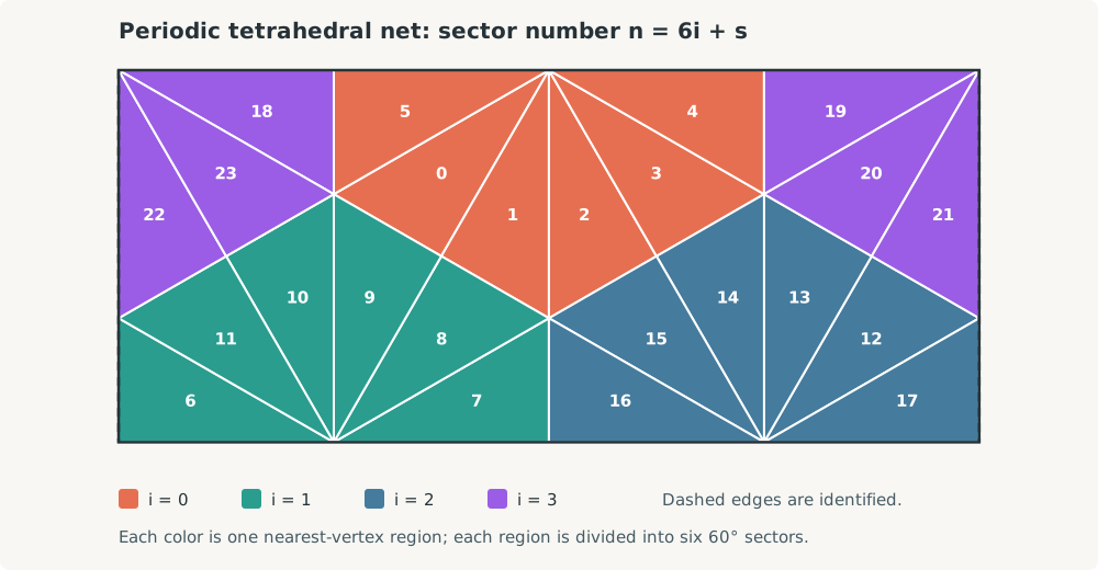
AuthaGraph tetrahedral-net illustration.
docs/authagraph-tetrahedron-net.svg.The diagram is a repository-native vector rendering of the exact 24-sector origin and rotation table in the C++ implementation. It is explanatory, not an independent numeric authority.
Terminology and claim boundary
The sources use several related descriptions of AuthaGraph. These documents use the following deliberately narrow language:
- “Original” or “earlier method” means the 96-region graphical/modeling construction documented in the 2017 paper.
- “Analytic formulation” means the conical approximation and equations published in 2022 and implemented here.
- “Equal-area type” is the official project’s qualified description. Neither the official page nor the 2022 distortion study supports claiming that this finite-subdivision implementation is locally equal-area at every point.
- “A3 compatibility” means coordinate registration to the checked-in drawing sheet’s map viewport; it does not mean pixel identity with the earlier construction.
These distinctions keep API documentation, mathematical provenance, and visual-asset provenance separate.
Documentation index · Geometric context · Implementation notes