AuthaGraph geometric context
Documentation index · Implementation notes · Bibliography
What kind of projection this is
AuthaGraph is a polyhedral, rectangular world-map projection. Instead of wrapping a cylinder or cone around Earth’s ordinary geographic axis, it places a regular tetrahedron in an oblique orientation, distributes the globe among four symmetric vertex regions, projects through a curved intermediate surface, and unfolds the result into a periodic rectangle.
The 2022 analytic formulation models the curved intermediate surface as four congruent cones. That model makes a direct latitude/longitude formula possible while retaining the design’s central goals: distribute distortion rather than concentrating it at the geographic poles, keep a rectangular world view, and allow the map to repeat in both planar directions.
flowchart LR
  G["Unit sphere<br/>latitude and longitude"]
  V["Four oblique<br/>tetrahedron regions"]
  C["Congruent cone<br/>analytic construction"]
  T["Regular tetrahedron<br/>24 symmetric sectors"]
  N["Periodic rectangular net<br/>4:sqrt(3)"]
  F["a60::carto::frame<br/>screen coordinates"]

  G --> V --> C --> T --> N --> F
The arrows describe mathematical stages, not temporary meshes in the C++ implementation. The code reduces them algebraically to a direct forward transform.
Why ordinary geographic quadrants are not the units
North/south and east/west quadrants are useful for reading a conventional map, but they do not control this projection. The tetrahedron is deliberately oblique to Earth’s axis so that no geographic pole becomes the unique center of the map’s distortion.
The implementation uses these four tetrahedron vertices:
| Vertex | Latitude | Longitude | Broad location |
|---|---|---|---|
p0 |
76° 52′ 51.82608″ N | 149° 27′ 03.56868″ E | Arctic Ocean |
p1 |
27° 57′ 09.99792″ S | 97° 21′ 25.2126″ E | eastern Indian Ocean |
p2 |
22° 55′ 41.65104″ S | 133° 16′ 57.93168″ W | South Pacific |
p3 |
6° 38′ 13.37028″ S | 18° 51′ 08.037″ W | South Atlantic |
For a unit geographic vector g, the selected region is the vertex p[i]
that maximizes g dot p[i]. The boundaries occur where two dot products are
equal. They are great-circle arcs and form four congruent spherical triangular
Voronoi regions.
Each pair of distinct vertex vectors has dot product -1/3; the angle between
them is therefore:
acos(-1/3) = 109.471220634... degrees
That is the central angle between vertices of a regular tetrahedron. The four vectors also sum to zero, placing the tetrahedron’s center at the sphere’s center.
Local pole and six sectors
After choosing p[i], the algorithm temporarily treats it as a local north
pole. The next vertex in implementation order sets the local prime meridian.
Local longitude around that pole divides the region into six 60-degree
sectors:
vertex regions:  4
sectors per region: 6
total symmetric regions: 4 x 6 = 24
The projection’s analytic derivation needs only one of these congruent 1/24-regions. Reflection, rotation, and translation place its result in every other position. This use of 24 symmetric regions should not be confused with the earlier modeling workflow’s 96 control regions: that workflow split each of the 24 regions into four additional pieces for its area adjustment.
Calling the units “sectors” or “1/24-regions” is less ambiguous than calling them quadrants. A global sector number is:
n = 6i + s

i = nearest tetrahedron vertex, 0 through 3
s = local 60-degree sector, 0 through 5
The 24-sector net
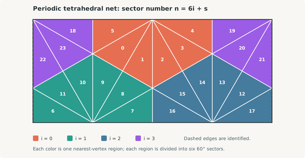
The diagram is generated from the same exact origin and rotation table used by
the implementation. Color identifies the nearest-vertex region i; the label
inside each triangular half-sector is n = 6i + s. The purple i=3 region is
split at the left and right sides because those vertical edges are the same
edge in the periodic plane.
Several apparently separate triangles therefore become neighbors when copies of the rectangle are tiled. This is the key to reading the layout: it is a single chosen window into a repeating tetrahedral net, not a claim that the left and right borders are geographically unrelated.
Within one canonical region, the important planar points are:
tetrahedron vertex       N' = (0, sqrt(2/3))
opposite-edge midpoint   O' = (0, 0)
outer edge endpoints        = (±sqrt(2)/3, 0)
Neighboring half-sectors share these edges to make the triangular faces of the unfolded tetrahedron. The explicit origin/rotation table then arranges those faces inside the rectangular period.
Where the aspect ratio comes from
The raw net uses a triangular lattice with fundamental edge scale:
l0 = sqrt(2/3)
Its complete period is four such units wide and sqrt(2) high:
W0 = 4 sqrt(2/3)
H0 = sqrt(2)

W0 / H0
  = 4 sqrt(2/3) / sqrt(2)
  = 4 / sqrt(3)
  = 2.309401076758503...
Every variable-sized map must preserve this ratio. Scaling both axes by the
same factor changes size without changing the triangular geometry. A familiar
2:1 world-map frame is close but is not valid for this AuthaGraph net.
Cuts, repetition, and map aspect
A globe cannot be flattened into one rectangle without cuts or distortion. Here, cuts follow selected edges in the tetrahedral net. After normalization, the horizontal coordinate uses modulo one, so the right boundary continues at the left boundary.
The implementation also applies a constant cyclic horizontal shift:
delta = -0.08797138953590078
Changing this shift slides the periodic world beneath the rectangular window. It changes which seam is visible and which geography appears near the center, but it does not change the projection inside a sector. The selected value registers the implementation with the checked-in A3 AuthaGraph drawing sheet.
AuthaGraph’s periodic construction admits other map aspects: tiled copies can be cut and centered differently to emphasize another ocean, continent, or relationship. This implementation exposes one fixed, tested aspect. A renderer must still split polylines that cross the chosen seam; otherwise it may draw a spurious line across the map.
From a location to a map point
The complete decision path for one coordinate is:
flowchart TD
  A["Validate finite latitude and longitude"]
  B["Convert to unit vector g"]
  C["Choose i by maximum g dot p[i]"]
  D["Build local longitude and latitude"]
  E["Choose 60-degree sector s"]
  F["Apply analytic 1/24-region formula"]
  G["Rotate and translate sector n = 6i+s"]
  H["Normalize and apply cyclic shift"]
  I["Scale to map_frame; invert y for screen coordinates"]

  A --> B --> C --> D --> E --> F --> G --> H --> I
At an exact tetrahedral boundary, multiple regions describe the same geometric
edge. The implementation makes the result deterministic by keeping the
lower-indexed vertex in a closest-dot tie. At -180 and +180 degrees, the
periodic normalization produces equivalent positions.
Relationship to the source drawing sheet
The repository includes
assets.static/authagraph/15-SP-TESD-03-AG.pdf,
a one-page A3 AuthaGraph drawing sheet. It serves two purposes:
- a visual reference for the graticule, cuts, and chosen world-map aspect; and
- a compatibility coordinate system for the named
ag_a3preset.
The map occupies a 4:sqrt(3) viewport inside the larger A3 page. Generic
projections use a map-only frame starting at (0, 0); ag_a3 instead returns
coordinates in the full page so projected geometry can align with that asset.
The 2022 paper documents that its formula uses a slightly revised intermediate surface and compares it with the prior construction. Consequently, small coastline and graticule differences between the analytic projection and the older plate are expected. The source asset supplies registration, not a pixel-by-pixel oracle.
Distortion in context
“Equal-area type” describes the design goal more accurately than an unqualified claim that every infinitesimal area is preserved. The official AuthaGraph description notes that further subdivision would be needed for a strictly equal-area map, and Narukawa’s analytic evaluation finds remaining local area distortion as well as angular and distance distortion.
The geometric benefit is distribution: four oblique tetrahedral regions avoid putting all exceptional behavior at the ordinary North and South Poles. No projection can preserve area, angle, distance, and shape everywhere. This one uses tetrahedral symmetry and a curved intermediate construction to balance those errors while retaining a rectangular, repeatable map.